Climate Change in the Himalayas
|
The Himalayas are one of the world’s most sensitive locations to climate change. Outside of the polar regions, the Himalayas contain the largest concentration of glaciers and are often referred to as the water towers of the world.1 Locals such as Nepalese indigenous communities are heavily dependent on glacial melt-water due to erratic precipitation patterns and the generally arid climate.6 Water is not only essential for drinking but for the irrigation of crops and daily uses. The 15000 glaciers located in the mountain range source 19 major rivers including the Yangtze, Ganges, Indus, Yellow and Mekong which provide water for approximately 1.4 billion people downstream. 4,5 These Glaciers act as reservoirs of freshwater, seasonally releasing melt-water for the people to use. As the glaciers shrink, the will the water supply of the people with follow. Another concern with the melting glaciers is the build-up of glacial lakes as larger volumes of melt water flow into these lakes which can burst and cause flash flooding.7 |

[6]
|
Glaciers in the Himalayas are retreating at average rates of 10-59m per year and in the past five years this rate has accelerated to 74m/year in certain locations.7 The 2014 simulation by the United Nations Climate Panel estimates a 45% reduction in total Himalayan glacier mass by 2100 if a 1.8˚C rise in the Earth’s temperature were to occur.10 The rise in temperature caused by global warming has been accredited as the main cause of Himalayan glacial melt though recent studies indicate it is not an excess in greenhouse gases that are behind the warming, but rather particulate matter pollution. Atmospheric brown clouds are accumulated layers of aerosols (fine particles suspended in a gas, usually air) created through the combustion of fossil fuels and biomass. They are primarily composed of black carbon (soot) which is produced from the flames of burning of fossil/biofuels. Soot is one of the largest culprits of global warming, second only to carbon dioxide. In the atmosphere, these black carbon particles absorb solar radiation, contributing to rises in the Earth’s temperature. These heated soot particles may also fall on glaciers, darkening their colour and further contributing to melting.11,12,13 In the Himalayas, soot is produced by the locals burning wood to in their traditional stoves because of the limited access they have to fossil fuels and electricity. Soot is also released through forest fires, factories and the exhaust from vehicles.2
 [7]
[7]
 [8] [8]
|
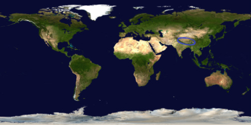
The Satellite Image on the left shows large clouds of grey haze. These clouds are aerosol layers produced from combustion, especially of wood in traditional stoves. These aerosol layers contain soot particles which absorb sunlight and fall on Himalayan ice after drifting North due the South-Easterly prevailing winds from the Indian Ocean. These soot particles not only increase surface temperature of the glaciers but lower their reflectivity, accelerating glacial melting. |
The 2007 Maldives Autonomous unmanned vehicle campaign flew several unmanned probes into the Indian Ocean atmospheric brown cloud in order to investigate its effects on solar heating. The probes measured concentration of aerosols in the region and their respective solar radiation absorption rates concluding that the effects of the local atmospheric brown clouds increased the region’s solar heating by approximately 50%. 90% of this heating was attributed to soot. 13 The effects of soot darkening on glaciers were also measured through several simulations conducted by NASA. It is estimated that the current levels of soot may cause up to a 3 percent decrease in the albedo (a measure of reflectivity) of Himalayan glaciers and that the resulting increase in absorption of solar radiation can enhance heating of the snow by up to 24%.14
[i]
|
[i]
|
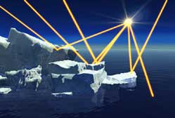
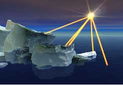
The diagrams left simulate the paths of the Sun’s rays on clean ice compared with ice darkened with soot. The soot lowers the albedo of the ice causing more wavelengths of light to be absorbed, heating the Earth and melting glaciers. The smaller ice cover then leads to less sunlight being reflected and more being absorbed. The cycle then repeats. |
|
Significant glacial melting will undoubtedly have extreme consequences on residents. While 80% of their water demands are supplied by the monsoon in the wet season, residents rely heavily on glacial melt-water, precipitation and underground springs in the dry season.6 With many springs dried up, large reductions in precipitation and the ever growing water demand in agriculture, the need for glacial melt-water has never been higher. Some of the most heavily affected are the more remote villages of Nepal and India where the residents do not have access to piped water. For example, in the small villages of India and Nepal, families are limited to filling their water vessels from wells once a day. In 2011, a study of the region conducted by the International Centre for Integrated Mountain Development, researchers observed an average 50% decrease in local water sources.6,15 The drying up of glacial fed streams has caused locals to turn to other less sanitary sources such as stone spouts while others have even been observed to fill their vessels from dirty leaking roadside pipes. In 2007, Nepalese science departments co-operated with the Central department of microbiology to test over 132 water sources in the Kathmandu Valley of Nepal. The results were extremely distressing as an overall 93% of wells and tap water were found to exceed the World Health Organisation (WHO) guidelines for a safe number of microbes in the water. 26.4% of the discovered microbes were strains E.Coli, well-known bacterium pathogens known to cause anaemia, acute kidney failures and urinary tract infections. This in combination with the warming climate (which allows a higher survival rate of microbes) severely increases the risk of a disastrous epidemic. An epidemic could easily spell disaster for the millions of people in the Himalayan region as the remote nations may not have easy access to modern medicine.15
|

[11]
Stone spouts (above) are an ancient water delivery system designed by the Nepalese thousands of years ago. They draw from groundwater , filtering the freshwater for use as it flows from the spout's mouth. However, since the system draws from shallow aquifers (rock reservoirs of groundwater), it is subject to surface pollution and all spouts have shown levels of contamination. Aquifers are also non renewable and with the glaciers rivers drying up, they will only deplete faster from more usage.

Family fills their containers with well water. [9]
|

[ii]
|
[ii]
|
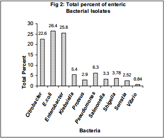
Figure [1] displays the microbe levels in four different sources of drinking water in the capital city of Nepal, Kathmandu. All water from the tap and stone spouts exceeded the WHO water guidelines while wells were not much better. Stone spouts are a drinking water-fountain like system designed by the ingenious ancient Nepalese and provide thousands of kilolitres of water to the people across the nation. While these contraptions have been utilised for hundreds to thousands of years, the microbe levels indicate that something will be need to be changed with the current system for eg. extra filters, replacement of the spouts etc. Figure [2] presents the percentage of different types of bacteria found in the local water sources. All these bacteria, namely salmonella and E.Coli, are known to cause infections. These infections account for up to 8% of deaths in Nepal and the amount of people using these water sources is only expected to rise as glaciers melt.28 The country is also relatively undeveloped and may not have the necessary resources to treat these infections.15,28
Climate change has also significantly affected agricultural practices across the Himalayan foothills. The warmer climates are causing a variety of negative effects from erratic precipitation patterns to the drying of streams and vegetation. The drying of grass cripples yak milk production as the Yaks require the grass to feed.8 In addition to receiving less water, fruit plantations have also been affected by pests which can now survive in the area due to the warmer climates. 71% of apple farmers in the lower foothills have experienced a significant decline in production and fruit quality.16 Increase in temperatures and reduction in moisture will also lead to more degraded land (and even desertification in extreme cases) as well as reducing the amount of arable land available for agricultural use. The recent World Water Council’s report on climate change in the Himalayas concluded that degraded land is rising at a rate of 3-5% per year. Yields are also expected to decline as much as 30% in the next century and the International Panel of Climate Change (IPCC) has projected a 6-10% increase in water demand for every degree Celsius that the temperature rises, threatening the food security of millions of locals.17
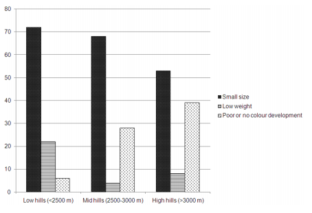
Figure 4 [iii]
|
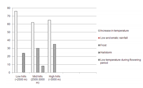
Figure 5 [iii]
|
Figure 4 (source 16) displays the percentage of deformed apple fruits in the Himachal Pradesh Area located between India, Nepal and Pakistan. The data is from a survey of a few hundred apple farmers in the region. It is clear that apples, one of the major grown fruits in the region is being severely affected with over 70% of farmers observing smaller sizes of the produce in the foothills and almost 40% having poor or no colour development. These abnormalities in the produce will result in a lower value on the market and threaten the food security of the millions of residents who rely on agricultural produce. Figure 5 compares the perceptions of farmers on what is affecting apple production. Overall in all three regions, approximately 70% of farmers believed an increase in temperature was to blame due to the sensitivity of the crop. Any solutions to climate change would not be immediate and farmers may have to switch to growing other crops in the warmer temperatures which would also require changes in farming techniques. These changes could be difficult or even expensive.
Climate change is also increasing the likelihood of flash floods and glacial lake outburst floods (GLOF). Due to the warmer temperatures caused by global warming, more melt water is accumulated, creating larger glacial lakes. These lakes are restrained by weak barriers of rock called moraine dams that could give way at any moment causing flash flooding and landslides which destroy nearby villages. The Himalayas are also constantly threatened by regional seismic activity which could easily dislodge large clumps of boulders holding back glacial lakes.17,18,19 Glacial lake outbursts are not unfamiliar to the Himalayan population. In 1981, a glacial lake outburst in the Bhutan Himalayas decimated local infrastructure, destroying several bridges and hydroelectric projects as millions of cubic kilometres of water were released in a few minutes. There are over 1600 glacial lakes in Nepal and over 200 have been classified as potentially dangerous. The fastest growing is Imja at a rate of 47m per year and contains 65 million cubic metres of water, enough to fill 26,000 Olympic sized swimming pools.17 A glacial lake outburst or flash flood could easily destroy surrounding farms, homes, infrastructure and cripple the area’s tourism, severely reducing the income of already struggling locals who are fighting against the odds of climate change. For example, in 2008, the Kosi river in the Nepalese Himalayas had its banks breached leaving over three million people homeless, stranded and hungry. Over a thousand villages were inundated and approximately 600,000 acres of cropland were destroyed, eliminating the majority of the area’s food sources. Total reconstruction efforts exceeded a billion US$, crippling the area’s economy for several years. 17,18,30
[iv]
|
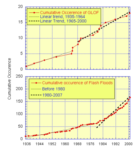
From the graphs of the United Nations International Strategy for Disaster Reduction (UNISDR), it is clear that the melting glaciers caused by climate change have led to significant increases the frequency of flash floods and Glacial Lake Outbursts. The two light and dark dotted trendlines show the large difference in numbers of flash floods/GLOF between the 1930s-1960s and the 1970s-2000s. There is a clear rise in the frequency of flash floods after 1964 and of GLOFs after 1980. Around the 1970s, oil production peaked in the U.S, Canada and numerous other countries indicating a correlation between fossil fuel use and the increase in flash floods.
|
